
Water, wildlife returning to Pacheco Marsh and Walnut Creek
KTVU Fox 2 Giving Day: Family Harvest Farm
February 22, 2022Thompson Honors John Muir Land Trust as 2022 Contra Costa County Climate Crisis Champion
April 25, 2022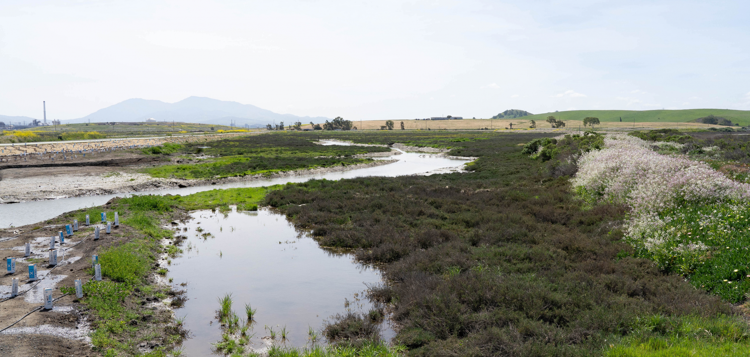
Native plants (at right) grow next to recently planted natives at the Lower Walnut Creek Restoration Project. (Photo by Ray Saint Germain/BCN)
‘Now that we’ve brought the tides in, it’s really starting to thrive and I’m happy to see that’
by Tony Hicks / BCN Foundation
Since the levees to Suisun Bay were breached nearly six months ago, the landscape of Pacheco Marsh has changed dramatically.
It’s closer to being a waterscape now, with the 5.32 miles of channels cut by earthmovers last year now full of bay water, flowing upstream or down, depending on the tide. Ribbons of yellow wildflowers — dotted with orange poppies — wind through the marsh.
Waterbirds are starting to appear — the rabbits and coyotes were already there, though they’re easier to find now that the wildlife preserve is taking more functional form (the coyotes were sighted right next to (of course) the coyote brush plants project manager Paul Detjens pointed out only a few minutes before).
There’s also about 31,000 milk cartons dotting the landscape, along with miles of irrigation piping that will remain for three years.
The milk cartons protect the native plants that have been put into the ground. The kind of plant depends on the zone and “how much salt water they like,” Detjens said. Much of it will be habitat for the marsh’s endangered salt marsh harvest mouse.
“They’re 100% native,” said Detjens, a senior civil engineer from the Contra Costa County Flood Control District. “There will be a mix of wildflowers and grass in the transitional zones. We’re not planting the tidal channel. That will be taken care of by seeds coming up with the tide.”
“Now that we’ve brought the tides in, it’s really starting to thrive and I’m happy to see that,” Detjens said.
The goal of the Lower Walnut Creek Restoration Project is to restore 300 acres to its natural state, before 19th century industry intervened.
Just over the hill from the Al McNabney Marsh — across Interstate 680 from the Martinez Refinery Co. — it’s the largest public works project in the county’s history.
The Walnut Creek watershed is Contra Costa’s largest, draining more than 150 square miles from eight cities into a marsh that, over the past century, became a dumping ground for dredging and an industrial buffer to the Bay.
Engineers want to enhance the area’s flood-carrying capacity, while naturalists want conditions closer to those existing before humans channelized the marsh and brought industry.
The marsh and Walnut Creek, on the marsh’s eastern edge, were home to grizzly bears, elk, salmon, and steelhead until the mid-1800s (opinions vary as to whether the restoration will bring back the spawning fish). Though Detjens said “Fish are beginning to come up and get fat and happy before they move on out.”
The wetlands got filled in over the years and merchant ships sailed up Walnut Creek. As the decades progressed, refineries were built and much of the area was forgotten.
The county bought 122 acres of the marsh in 2003 from a towing company that previously planned a junkyard there. Nearby Marathon Oil refinery bought another 18 adjacent acres formerly used for sand mining and donated it to the land trust in 2020.
Detjens said the project has been meticulously and scientifically planned, down to the exact spot of each plant.
“It’s something different than ‘We build a meadow and we wait for the rain to keep the plants alive,'” Detjens said. “This is really an estuary in that it takes water coming in from the bay in an interface with the ground water. It’s a little more complex nuance of how it’s re-vegetated.”
It’s also been planned with the future in mind.
“This is actually the area that we designed for sea level rise adaptation,” Detjens said, standing on what will become a trail. “Instead of having a steep slope, we have this gradual slope, so as sea levels rise in the decades to come, that habitat can actually slowly migrate upslope and the plant communities can evolve and change as conditions change. That’s one of the reasons why you don’t see a traditional levee with a real steep slope here.”
The John Muir Land Trust will manage the site, which they’ve said will become a bird-watching destination. Even before the project started, more than 80 species of birds at Pacheco Marsh, including the short-eared owl, white-tailed kite, American kestrel, northern harrier, and the loggerhead shrike.
The land trust will get to work later this year, developing 2.6 miles of trails on 140 acres, with multiple elevated vistas for bird watching, and other educational resources. The marsh will also feature three kayak ramps, a staging area, and a parking lot at the marsh’s south end.
“Once built and opened to the public, these public access elements will offer environmental education and wildlife-compatible recreation for local and regional visitors for generations to come,” John Muir Land Trust Executive Director Linus Eukel said, in an email.
Detjens pulled non-native plants from the ground as he spoke. He said the project is one of the high points of his 30-year-career.
“This whole area, the life is coming back to it,” Detjens said. “We’re very pleased to see the plan is coming together and it’s actually working.”